

VIDEO
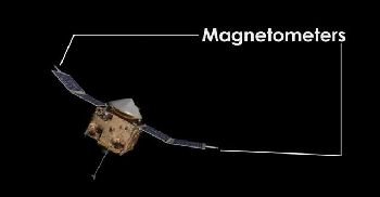
Magnetometers
The location of the magnetic poles can be figured out from the study of rocks with magnetic particles.
The rocks’ particles are still aligned with the magnetic poles that existed when they were formed. From studying these rocks, scientists have learned that the magnetic North Pole has moved, over the past 500 million years, from just north of the Philippines in the Pacific Ocean to its more northern location today. Actually the poles are in the same place, but the crust’s movement makes their locations appear to migrate like birds.
The magnetic characteristics of underground formations can be measured to figure out geological and geophysical information. This is done through the use of magnetometers, which are instruments that measure small differences in the Earth’s magnetic field. The first magnetometers were big and bulky, and could only survey a small area. In 1981, however, NASA launched a satellite, equipped with magnetometer technology. This satellite, known as MAGSAT, could take magnetic measurements on a continental scale. It allowed geologists to study underground rock formations and the Earth’s mantle. MAGSAT also provided clues to landmass movements and the location of deposits of natural gas, crude oil, and other important minerals.
Gravimeters
Geophysicists also measure and record the difference in the Earth’s gravitational field to better understand underground structures. Various underground formations and rock types have different effects on the Earth’s gravitational field. By measuring minute differences between formations, geophysicists can study underground formations and get a clearer idea of what types of formations lie below ground, and if they contain resources like natural gas. If sailors were around to navigate the Earth’s oceans millions of years ago, their compasses would have still pointed to the magnetic North Pole or ‘‘true north.’’ However, they would have sailed to entirely different places on the wandering and shifting crust than they would have today when following the same compass. The Earth is just not the same as it was millions of years ago.
A geologist’s job is to figure out how it has changed and try to predict what it will do in the future. Now that you have a general idea of the birth and characteristics of our home planet, let’s study the forces that have continued to shape the Earth.
Earth since those early days
We will learn more about what scientists think might have happened during the early history of our planet when it first became solid and later began to develop character.
Quiz
1. What percentage of water covers the Earth’s surface?
(a) 40%
(b) 50%
(c) 70%
(d) 80%
2. Aristotle was the first person to notice that
(a) The Moon was round
(b) Mice always live near grain barns
(c) Bubbles appear in fermenting liquids
(d) The Earth’s shadow on the Moon was curved
3. What is the nearest major galaxy to the Milky Way?
(a) Orion
(b) Draco
(c) Andromeda
(d) Cirrus
4. When space debris measures about 350km miles across it
(a) Breaks apart
(b) Forms a sphere
(c) Loses its crust
(d) Becomes a meteor
5. The magnetic pole is
(a) Constantly moving
(b) Located exactly at the geographical pole
(c) Only observed in the southern hemisphere
(d) Based on observations of the tides
6. The lithosphere is
(a) Located below the ionosphere
(b) The crust and very top part of the mantle
(c) Roughly 5–20km thick
(d) Fluid and soft in all areas
7. When solids flow, it is known as
(a) Flexibility
(b) Plasticity
(c) A mess
(d) The magnetosphere
8. The Sun is approximately how many million miles away from the Earth?
(a) 54
(b) 75
(c) 93
(d) 112
9. The biosphere includes the
(a) Hydrosphere, crust, and atmosphere
(b) Oceans and trenches
(c) Crust, mantle layer, and inner core
(d) Hydrosphere and lithosphere
10. The polar magnetic current is
(a) Very limited in area
(b) Only found around the equator
(c) The true north of a sailor’s compass
(d) Called the magnetosphere
