

Mantle
The mantle, also known as the mesosphere, lies just beneath the crust. It forms over 83% of the Earth’s volume and about 58% by mass. In the mantle, earthquake waves jump suddenly in speed (velocity) from the way they travel through the crust. This jump is determined by the change in density between the crustal rock and the denser mantle rock.
This discontinuity between high and low velocities is called the Mohorocicˇic´ discontinuity or Moho for short. It is named after a Croatian seismologist and meteorologist, Andrija Mohorocicˇ ic´, who first noticed its strange behavior after looking at seismic waves from the Kulpa Valley, Zagreb, Croatia earthquake in 1909.
Mohorocicˇ ic´ discovered that seismic waves came in two separate sets. Naming these wave sets, P- and S-waves, he noticed that one set arrived earlier than the other during the course of the quake. It was
Mohorocicˇ ic´’s thought that one set had traveled through denser material than the other and was slowed by it. He proposed a theory that the Earth’s outer rocky crust is about 30km thick and rides on top of a denser mantle beneath it.
The Mohorocicˇ ic´ discontinuity is the boundary between the crust and the mantle.
When geologists began to track this wave change, they weren’t sure what it meant and they tested a lot of different theories. As they gathered more and more measurements, they found that the speed of the P- and S-waves followed the variations in the thickness of the crust. This was seen in crust measurements from about 35 to 40km below the continents and about 10km below the oceans. However, below some high mountain ranges like the Andes, it can be as deep as 70km in places.
This boundary between the crust and mantle became known as the Mohorocicˇic´ discontinuity. Research has fine tuned this slowing and found the seismic waves travel nearly 20% slower below the Moho than above it.
Most seismologists consider the Mohorocicˇ ic´ discontinuity, where it meets the upper mantle, to be the bottom or deepest limit of the Earth’s crust.
Buoyancy
When geologists studied earthquake data further, they found that the crust was thinnest under the oceans and thickest below high mountain ranges. It was the thickest at the highest elevations and thinnest at low elevations. In other words, the Moho crustal boundary provides a mirror image of the crust above it.
This mirroring is based on buoyancy. The less-dense crust is floating on the pliable asthenosphere layer. Since buoyancy depends on thickness and density, the Moho boundary effect is a lot like that of an iceberg floating above the surface of the ocean. Icebergs float with only 10% of their volume showing above the waves. The density of water is 1.0, while the density of ice is 0.9 (because of the air trapped in the frozen water). The ‘‘tip of the iceberg’’ happens because ice is 10% less dense than water and 90% then, of the iceberg’s volume is below the surface.
The continental crust is thicker under high mountain ranges to balance the floating ‘‘tip’’ above the land surface. Some geologists estimate that the depth to which a mountain’s ‘‘foot’’ descends into the denser mantle is about 4 ½ times the elevation of the mountain above. If this is true, then Mount Everest which stands about 8km high must be supported by a crustal foot that reaches nearly 36 km, in addition to the 35km of existing continental crust.
The oceanic crust is much thinner with few thickened spots. This is because it is made up mostly of mafic minerals that are heavy in iron and magnesium compared to the continental crust made up of mostly felsic minerals, richer in lighter, aluminum-bearing silicates.
Much of the Earth is made up of two pairs of elevations. One pairing is between 1000m and sea level and the other pairing drops from sea level to 4000–5000m below sea level. The first pairing includes the crustal continental platforms while the second pairing describes the abyssal oceanic plains.
The balance between these two layers overlying the mantle allows density equilibrium to be maintained. The thickness gradient then allows for continental mountains and ocean basins. Ocean basins are low spots where water gathers, but flows across the lithosphere. Continental shelves create a gradual boundary into the oceans.
Temperature
Depth tests of mine shafts found that for every 60 feet drilled deeper into the Earth’s surface, the temperature increased by one degree Fahrenheit.
1ºFahrenheit up/60 feet down in depth
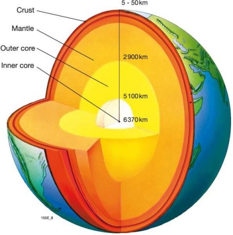
The deepest shafts drilled into the Earth have been to a depth of about 13 km, but this is just a tiny prick compared to the total depth of the mantle. The entire mantle of the Earth is about 2897 kilometers (1800 miles) thick. Figure 3-5 gives an idea of the size comparison of different layers of the Earth and their incredible depths.
Core samples are rock layer samples taken by drilling or boring at different depths of the mantle and bringing long cylinders of rock.
Bore holes and core samples are important in other ways. They give us information on the layering of the mantle as well as its makeup. Samples canbe analyzed for their content and percentages of different elements. Just like a core sample from a tree, a rock core sample shows different growth (or sedimentation) and composition patterns.
Electrical instruments that measure conductivity can also be used to take a look at the electrical properties of different layers of core samples. A sonic generator can be eased into a bore hole to provide a sound source to measure acoustic variations. Other sensors can be used to detect naturally occurring radioactivity levels of different elements in the layers of the crust. A combination of research tools are used individually and in combination with others to tell the overall picture of an area’s geological profile.
For every kilometer drilled into the Earth, the temperature increases along a thermal gradient between 15 and 75ºC depending on location. Just as the temperatures at the center of the Earth are extreme, the pressures are equally as intense. Temperatures have been estimated to be as great as 6000ºC, with crushing pressures of 300 million kilonewtons per square meter or about three million atmospheres within the core. The size of the Earth allows a huge amount of energy to be stored within it as heat. The original heat of the planet is maintained by the constantly produced transformation, generation, and release of energy from radioactive elements.
Anyone traveling to the Earth’s core would require vehicles found in science fiction that could withstand the intense heat and pressure. Otherwise, they would be fried and flattened like pancakes, not a good end for someone wanting to satisfy their scientific curiosity.


