

Key beds
To help them follow lithographic changes, geologists use key beds as a marker to certain types of rock. This is particularly useful to geologists that live and work in a certain area for many years. The key beds are so familiar that they are almost like old friends.
A key bed is a thin, broad bed with very specific characteristics that are easily seen and recognized.
Key beds can be tagged from one outcrop to the next, even miles apart, if their main characteristics are specific enough. Color can be a big player in key beds. A thin, black layer of volcanic ash, easily seen on top of pale tan silts or sandstone, can be used to correlate many key beds in a region. It makes sense, then, that if separate key beds are able to be correlated, then the strata just above and below the key bed would correlate as well. This sameness of the stratigraphic column helps geologists match key beds, formations, deposits, and time periods. It is one of the main factors used in figuring out relative time connections between regions.
Electrical, radiometric, and fossil dating factors
Well samples taken from drilled holes in sedimentary petroleum-rich areas can be compared as well. Just as tree core samples have rings of growth, so too do rock core samples. Along with actual samples, energy companies also use instruments that can be lowered into drill holes to read electrical properties of the layers below. In this way, they read sedimentary shifting across distances and determine where to drill next. Radiometric dating is used to get much closer to actual age when dating sedimentary rock samples. This type of dating is fairly direct except when other types of rock, like igneous rock, cut through the sedimentary rock layer being tested. It is important to remember that radiometric dating, like most mathematical calculations, have a standard error or deviation from the calculated number. Radiometric dating is thought to have between 5 and 20% standard error when dating rocks thought to be millions of years old.
Another type of dating factor used when comparing layers is a biological factor. Geologists look at the types of plants and microorganisms living in the sediment at the time it were deposited. For example, if an animal was found on the Earth only 500,000 years ago, it would be impossible (or at least very wrong) for a layer containing fossils of that animal to be dated at 80 million years ago.
The upper and lower boundaries of a formation are determined by their characteristics. These may be marked by unconformities or guide fossils; fossils repeatedly found to be associated with a certain period of time.
Guide fossils are those wide-spread genus and species of fossilized organisms found within a specific rock-stratigraphic unit.
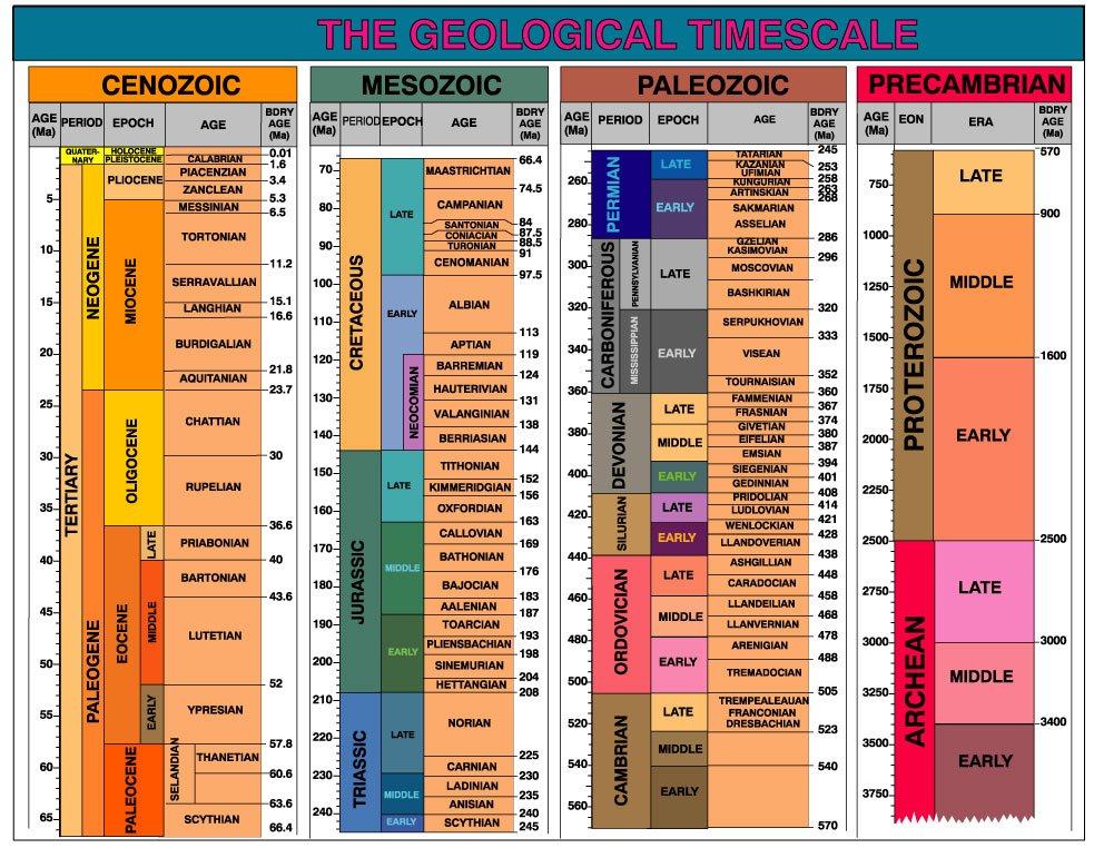
GEOLOGIC TIMESCALE
When geologists gather an area’s data together to decipher the total geological picture, they consider the known key beds, strata, and formations in chronological order and include electrical, radiometric, and fossil information. This stratigraphic analysis helps them figure out the geologic timescale. This timescale is divided into four major eons that have been decided on the basis of the life that lived during that time.
The four major divisions of the geologic timescale are the Hadean, Archean, Proterozoic, and Phanerozoic eons.
The first eon is known as the Hadean eon. Hadean, Greek for ‘‘beneath the Earth,’’ is the earliest rock record. This most ancient rock is also found on other planets that don’t have constant volcanic activity to change it from the original. The second eon is the Archean eon, a slightly less ancient eon. The third eon, the Proterozoic, is thought to have seen soft multicelled microorganisms, but much of this rock has been weathered away or changed. The fourth eon is the Phanerozoic. This last major eon contains hard-shelled microorganisms that are fossilized and studied today. It is this last major eon, the Phanerozoic that has been further divided into the eras. These are the Cenozoic, Mesozoic, and Paleozoic which are then further divided into the Quaternary, Tertiary, Cretaceous, Jurassic, Triassic, Permian, Pennsylvanian, Mississippian, Devonian, Silurian, Ordovician, and Cambrian periods, respectively. The Quaternary and Tertiary are further subdivided into seven epochs of the Holocene, Pleistocene (Quaternary) and Pliocene, Miocene, Oligocene, Eocene, and Paleocene (Tertiary). Since the time frame described is so long, it was easier to divide it up into manageable chunks.
The life forms found in these different eons and eras were individual enough to set them apart from the earlier ones. Periods and epochs, however, tend to have blurry boundaries.
When Charles Lydell came up with the idea of uniformitarianism, he based it on the fossil communities found in the sedimentary rock of samples taken in Italy and France. These references are important in the general concept of similar fossils being found together, but today we can find more variety around the world in sedimentary rock than what Lydell knew about at the time. As better methods of uncovering fossil and rock samples are developed, we will have even more information and may break down the timescale again.
STRATIGRAPHIC BOUNDARIES
Timescale subdivisions of sedimentary stratigraphic units are based on their community makeup. The microscopic inhabitants of strata and the way they change over time are very important in relating time periods to each other. Figuring out whether organisms came on the scene earlier or later than others, depending on development, is a question geologists ask. These organisms are found mostly at the sites of ancient seas and oceans, but land-based animals are also used to figure out timescale. Stratigraphic boundary changes, then, seem to be based on all inhabitants, land, and sea, in a specific area.
When geologists find a major event that killed off, depleted, or shifted the majority of strata’s inhabitants, they try to place it. These events arethought to be related to a catastrophic event like earthquakes, volcanic eruptions, or something equally sudden. When these catastrophes take place, along with constant tectonic activity, strata can have very different compositions.
Some geologists think stratigraphic boundary changes depend on global climate changes. These changes are thought to occur as a result of sea level rise and fall and tectonic clashes. When the oceans of the world are lower, like during times of heavy glaciation, the exposed land forms can be eroded by wind and rain. Erosion in an area reduces and may even eliminate known strata. Later (thousands to millions of years), when a warming in global temperature melts frozen ice, the seas rise, land is covered again, and sediments are deposited again. Study of the fossil strata of continental margins has found times when the seas covered much more of the land than they do now. The early Paleozoic Era and Cretaceous Period show a thick layer of marine sedimentary rock on nearly every continent during this time. The stratigraphic record experiences erosion of the sedimentary rock only during times of the fall in sea level.
When these same locations are sampled, a buildup of sediment during times when the water level increased again is seen. As plate tectonics shove and push continents around, the shape of ocean basins is changed. Sometimes the land crustal mass is increased and sometimes the ocean crust is increased in area. This depends on subduction and other tectonic forces.
Think of it like building a sand castle at the beach. Depending on the castle’s shape and surrounding moats, distance from the water’s edge and tide level, the details of the feudal kingdom will remain for a long time or will be quickly washed away.
Other experts believe a huge global impact from space caused the sedimentary deposition of a thin clay layer seen in many parts of the world. This clay layer, called the ‘‘boundary clay,’’ has been found to contain highlevels of iridium and platinum elements. Usually found in very low levels of different crustal rocks, this clay layer is thought to have come from the great amounts of rock and dust thrown into the air upon impact. The incinerated
forests and vegetation would have caused fires and smoke that blocked out sunlight for months to years. Photosynthesis would have been blocked, killing off plants that provide food for larger creatures in the food chain. In addition, a sharp drop in solar heating would have thrown the Earth into a cold period. The cold would have intensified ice formation and encouraged an ice age. Sedimentary rock samples taken in the western United States show that plant populations were radically changed at the end of the Cretaceous Period, with some species becoming extinct at the iridium rich clay layer. Then the next sedimentary layer shows fern growth, a plant that pops up following major ecological change. Geologists have supported this comet/meteor impact theory with calculations that an object, roughly 10km in diameter, impacted the Earth at the time of the Cretaceous/Tertiary boundary. Statistical research has shown that an impact once every 100 million years is likely. For the Phanerozoic eon (570 million years), five major extinctions have been studied or about one every 100 million years.
However, some geologists think this same boundary clay could have been caused by a period of intense volcanic activity. Something likes all the volcanoes of the world going off at the same time. It’s hard to tell what happened, but the layer exists. It is perhaps best used as a time-stratigraphic marker in the geologic column.
When correlating strata based on physical and biological information, there are many different characteristics to consider. A geologist trying to decipher the thickening and thinning of sedimentary rock over time looks at many different geologic sites and samples. The main thing to remember is that the Earth holds lots of clues to its past. We don’t have to puzzle over our past empty handed. For the person who likes mysteries, geology holds a lifetime of fun.


