

VIDEO
NASA – Topex / Poseidon Oceanography Mission Ends
Measuring Sea Level from Orbit
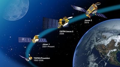
Satellite observation beginning in the early 1990s provided more accurate measurements than before and provided nearly global coverage. Satellites use a technique called radar altimetry that determines the distance between the satellite and the surface below based on the time it takes for a radar signal to traverse that distance.
The Ocean TOPography Experiment (TOPEX) Poseidon satellite, a cooperative effort by the United States and France, had been in operation from 1992 until 2006. A successor (TOPEX Jason) went into operation in 2001. These satellites have been providing global data on sea level and the complex patterns that form in the open ocean covering 95 percent of the earth’s waters.
The TOPEX satellites make an absolute distance measurement with respect to the center of the earth. By doing so, they are able to avoid difficulties associated with making measurements in relation to a fixed point on a nearby coastline. These data show a significantly higher rate of sea level rise than in the previous half century and are confirmed by coastal gauge measurements. Satellites since 1993 show that sea level increase varies from region to region. The largest rise was found in the western Pacific and eastern Indian Oceans. Nearly all the Atlantic Ocean shows a sea level rise over the past decade. Sea levels in the eastern Pacific and western Indian Ocean have been falling. Some changes are influenced by atmospheric patterns such as the El Niño southern oscillation (ENSO) and the North Atlantic oscillation (NAO).
Separating the Movements of Earth and Oceans
The earth seems very solid to us. But when the earth supports a massive weight such as the polar ice sheets and glaciers, it compresses a little bit like silly putty. As the ice melts and the weight is removed, the earth springs back. This can take thousands of years and continues long after the ice is gone completely. This process is known as global isostatic adjustment (GIA). The last ice age occurred 21,000 years ago, and the earth is still “snapping back” to the shape it had before it bore the mass of the glaciers.
It is necessary for scientists to isolate possible vertical movements of land. Tide gauges measure sea level. These measure the average sea level with respect to a reference point on the land. As with temperature measurements, anomalies-or departures from the established baseline-are what are tracked and reported primarily. The gauge measurements are only as good as the stability of the land used as a presumably constant reference point. Scientists cannot make accurate gauge measurements along coastal areas prone to tectonic movement or earthquake activity, such as are found near Alaska, India, and Japan.
The problem is that GIA is roughly the same order of magnitude as the sea level changes that scientists are currently measuring. Gravity Recovery and Climate Experiment (GRACE) satellites measure the changes in land elevation caused by GIA. Unless corrected for, GIA will give an exaggerated measurement if occurring under water. It will give an understated reading if the coastal area is rising, causing the sea to appear lower by comparison.
What causes sea level to rise?
There are two ways to raise the sea level:
1. Increasing liquid volume. Sea level will rise if melting glaciers or ice caps increase the volume of liquid water to the oceans. If you pour more ice tea into a glass, it will go to a higher level. This accounts for about half the rise in sea level.
2. Thermal expansion. The oceans are like a huge thermometer with all the liquid in the bulb. When the temperature of the oceans increases, the liquid water-like just about any other material-will expand. This also results in a larger volume, which is responsible for roughly the other half of the measured sea level increase.
Back-of-the-envelope calculation: Global Sea Level Increase from Themal Expansion
Determine the sea level increase resulting from the following (highly simplified) assumptions:
• The earth’s radius is 6370 km.
• Water expands by a fraction that is 0.0021 of its original volume for each degree Celsius.
• The oceans are heated by 0.1°C (uniformly) to a depth of 0.7 km.
• The oceans occupy 70 percent of the earth’s surface.
• The surface of a sphere = 4πr2.
• π = 3.14.
• 1 km = 1,000,000 mm.
Solution
The surface area of the earth’s oceans = (70%) × 4π (6370)2 = 350,000,000 km2.
The volume of earth’s oceans absorbing heat = 0.7 km × 350,000,000 km2 = 250,000,000 km3.
The oceans expand 250,000,000 km3 × 0.00021 × 0.1°C = 5250 km3.
The height increase = volume expanded/area = 14.6 mm.
At a rate of 1.8 mm/year, during the 42-year time period, global sea level rose 76 mm.
Comment: Thermal expansion accounts for about one-quarter of the sea level rise. This simplified calculation shows that sea level rise was consistent with the contribution expected for this time period.


