What Shapes a Region’s Climate?
Weather is the state of the atmosphere in a given place at a given time.
While “hot” may describe the weather for a March day in Fairbanks, Alaska (at least relative to other March days), it does not describe the March climate of any part of Alaska. Climate is the long-term average of a region’s weather. A region’s latitude and position relative to the major wind belts are two important factors that determine that region’s climate. The location’s climate also depends on whether or not it is near an ocean, what types of ocean currents are nearby, where it is relative to mountains, and the local albedo.
Latitude
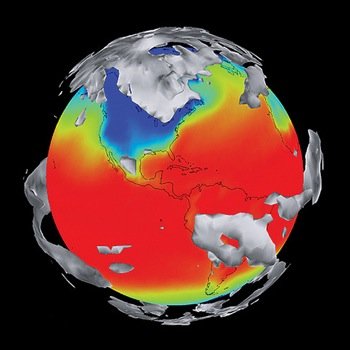
Although the heat budget of Earth as a whole is fairly well balanced, that is not true for the heat budget at different locations. The low latitudes near the equator take in much more solar radiation than the high latitudes near the poles because:
The Polar Regions receive no sunlight at all for months at a time in the winter, while at the equator, day length shows little seasonal variation.
Near the poles, even in the summer, the Sun never rises very high in the sky, so its rays are filtered through a great wedge of atmosphere before they reach the ground. Near the equator, the midday Sun is always overhead, so much more solar radiation reaches the Earth directly.
The Polar Regions are often covered with ice and snow, and their high albedo reflects back a high percentage of the solar energy that comes into the atmosphere.
This imbalance of entering solar radiation between the low and high latitudes is what drives atmospheric circulation.
Atmospheric Circulation
The atmosphere flows in great convection cells as it moves heat from the warm equatorial region to the cold Polar Regions. Near the equator, warm air rises. When the rising warm air reaches the top of the troposphere, it moves toward the poles. The air cools as it flows and becomes dense enough to sink at latitudes of about 30°N or 30°S. When this air reaches the surface, it is sucked toward the equator by the rising air, warming as it goes. The horizontal motion of air along the ground creates wind. When the air returns to the equator, the convection cell is complete. Convection cells are located at latitudes between 30°N and 30°S, 50° to 60°N, and 50° to 60°S, and at the poles. Earth’s rotation influences the direction air moves by means of the Coriolis effect, which is the tendency of a freely moving object to appear to move to the right in the northern hemisphere and to the left in the southern hemisphere due to Earth’s rotation.
Atmospheric circulation cells set the framework for a region’s climate. Where the air is rising or sinking at the equator, at 30°, at 50° to 60°, and at the poles there is little wind. Because air cools asit rises, and cool air can hold less moisture than warm air, locations where air rises (low pressure zones near the equator and at 50° to 60°) have high levels of precipitation. Locations where the air sinks (high pressure zones near 30°) experience more evaporation than precipitation. Air moves horizontally from high to low pressure zones, forming the major wind belts, which include the trade winds, between the equator and 30°N and 30°S; the westerlies, between 30°N and 30°S and 50° to 60°N and 50° to 60°S; and the polar winds. Convection cells are the framework for atmospheric circulation, although other factors also influence the force and direction of wind.