


Stratigraphic Classification
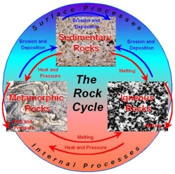
The Earth’s crust is constantly changing inside and out. Sedimentation and erosion processes are high for long periods (millions of years) and then something changes and they slow or stop. As we saw with plate tectonics, continental landmasses are shoving and compressing at their margins, while ever-widening ocean ridges spread apart. The crust is always on the move and brings about everything from nearly bottomless trenches and impossibly high mountains to crystalline beaches and black lava fields.
Our ‘‘blue planet’’ is anything but boring. Unlike newly erupted igneous surface rock, sedimentary rock strata give us snapshots of individual climates and geological events throughout history. When geologists put all these snapshots together, it creates a ‘‘family album’’ of all the species, habitats, landscapes, and temperatures of the Earth. By studying layers of different kinds of rock, geologists get not only knowledge of strata composition, but also a window into the experiences and influences that were in place during a specific time period. Geologists pull all this mixed information together in a system of stratigraphic classification that can be used by scientists all over the world.
ROCK STRATIGRAPHY
The study of rock stratigraphy is basically a grouping exercise. It reminds me a lot of the sorting exercises we did as children. What belongs with what? Which of these things goes together and in what order? At first glance, the many layers of a sedimentary rock structure look like a crayon box full of different colors or an artist’s box of paints. Differences are easily spotted between natural tones and earthen hues. But in addition to that, geologists have the added benefit of texture. Some layers are thin, some thick, some rocky, and some smooth, but all have a place in the geological stack. Each particular band added together makes up thetotal vertical picture. Some layers are separated by unconformities. The Grand Canyon is a well-known example of stratigraphic sedimentary rock layers that lie above metamorphic and original plutonic rock.
An individual band in vertical strata, with its own specific characteristics and position, is called a rock-stratigraphic unit or rock unit.
When several rock-stratigraphic units are stacked vertically, they add up to a formation which geologists can then describe and map as part of the geological record. Formations are collections, then, of many rock-stratigraphic units grouped together into a section with the same physical properties. Formations are commonly thick enough to be seen in a lot of different places where various strata layers are exposed. Igneous and metamorphic rock layers also have specific formations. Two or more formations can also be bunched together into groups. When drawing geological maps, different formations are called by name like the Green River formations. When naming a formation, geologists usually use the name of a surrounding area or the formation’s major stone type, like the red sandstone formations in Red Rock Canyon, Nevada. For even more detail, geologists subdivide the physical characteristics of formations into smaller rock-stratigraphic units called members and even smaller divisions, called beds.
When studying sedimentary rock strata, even more than igneous or metamorphic rock, it is important to remember the huge stretches of time that have led to the layer upon layer of solidified rock. Thousands and millions of years have added atom upon atom, crystal upon crystal to slowly build each layer. It is a lot like watching paint dry multiplied a million times slower. In order to better understand the super slow deposition of sedimentary rock, geologists divide strata by periods of time called timestratigraphic units. Then, when they are discussing a certain formation, they can further divide it into sandstone formed at one time, compared to nearly identical sandstone, formed much later.
Time-stratigraphic units are the rock layers with known characteristics that formed during a specific period in geologic time.
Time-stratigraphic units are commonly based on the fossil groups they contain and are sorted to represent progressively shorter time periods. These major groupings are combined into systems and systems are combined into erathems. Smaller geologic time units are further divided into eras, periods, epochs, and ages. These help to further track changes in stratigraphic rock layers over time.
DIACHRONOUS BOUNDARIES
Sometimes the upper and lower margins in an area are slightly different from the main body of the sedimentary facies. This happens in an area where sedimentary deposition increases as more of a changing gradient than a one-time event.
Diachronous boundaries grow at different rates both laterally and with respect to time.
In a river delta or marshlands area, for example, where some sections are dry, some marshy and some marine, the deposition rate of each area can be changed by the amount of local rainfall, temperature, and commercial activity. If a massive storm comes along one year and washes away lot ofthe silt collected in one area, then the silt replacement in the following years will be younger than the untouched prestorm silt buildup.
In the same way, the increasing front edge of a silting river delta is younger than layers below it or sections higher up the river.
Diachronous boundaries are found in areas where sedimentary rock is laid down at different times in different areas.
When changing sedimentation occurs with diachronous boundaries and then becomes rock, the related time lines can be traced from further up the river, down the slope of the piled silt, to the delta’s leading edge of buildup.
STRATIGRAPHIC COLUMN
Although rocks are grouped together by time and composition, they can also be grouped together into broad sequences of strata separated by major unconformities. These unconformity-limited sequences are made up of strata that have margins at the base and top by area and regional unconformities.
Geologists use seismic stratigraphy to outline these sequences. Through the use of high-resolution seismographs, the stratigraphic column can be finely detailed in most of its layers. By getting a cross-section of crustal rocks and sediments, seismic profiles of specific structure, thickness, regional environment, and unconformities can be drawn up.
Regional unconformities can be mapped across broad sedimentary rock basins within a subcontinent. Sometimes they are pushed up and folded bytectonic activity. Sedimentary rock solidification in a specific sequence can also be found stretching across a continent all the way to the continental shelf. By using seismic profiles, global spreading and layering of sediments can be followed from continent to continent to show how they might have originally looked when they were in larger land chunks.
Lithology is the study of the physical characteristics of a rock through visual recording or with a low-power microscope or hand-held magnifying glass.
Lithologic similarity is the matching of different rock formations separated by small and great distances by their physical characteristics. These physical characteristics include the following specific traits:
* Grain size,
* Grain shape,
* Grain orientation,
* Mineral content,
* Sedimentary structures,
* Color, and
* Weathering.
The main drawback of this type of comparison is when the distance is so great between formations that environment and weathering can make them look very different. The topography of an area rising above a lower plain can also make identification tough. Plants and trees add to the problem, but can be useful if viewed from the air. Geologists use changes in different plant growth as a clue to the soil. Some plants can’t grow in sandy or rocky soils, so show different growth patterns according to their base soils. Geologists study these growth preferences to figure out where collected sediments start and stop.


